
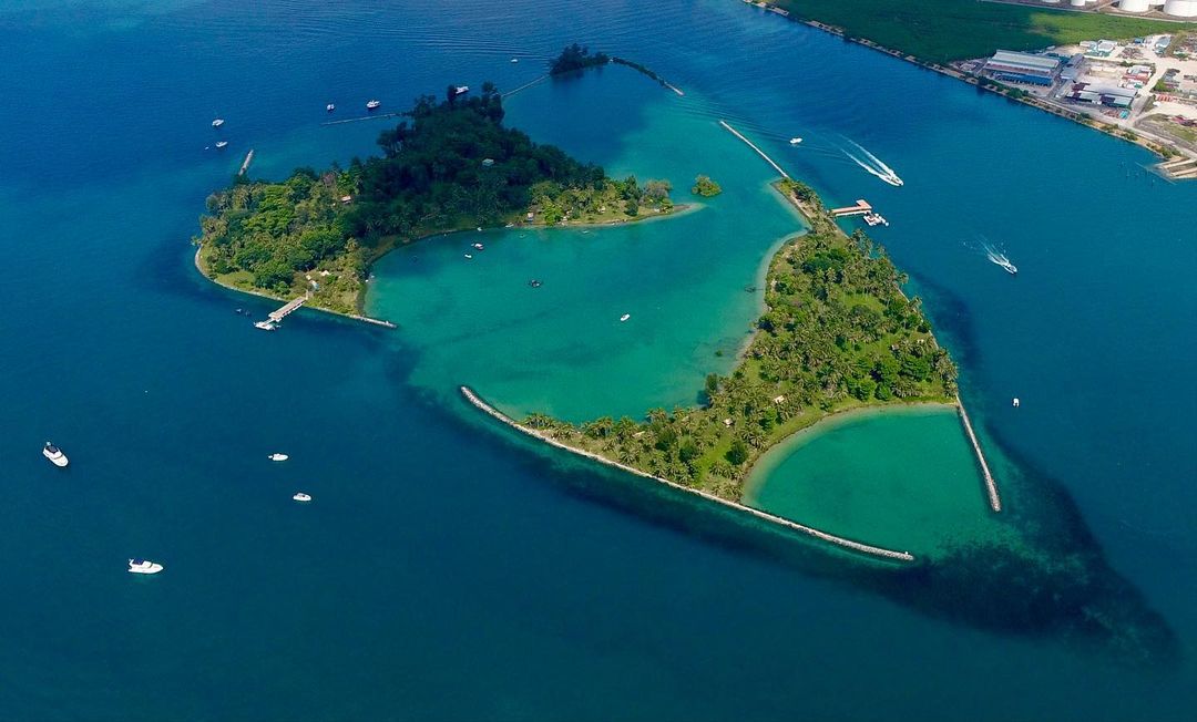
Image credit: @theboatshopasia via Instagram
For generations, Singapore has created room for its future by extending its shoreline. Reclamation helped form Jurong Island, expanded Changi and reshaped much of the coast familiar to us today. But a newly announced plan for the western islands has brought an unusually difficult question to the surface: how should a land-scarce country balance long-term development with the conservation of marine habitats that cannot simply be rebuilt elsewhere?
At the centre of that debate is Pulau Hantu, a small pair of islets that has an outsized place in Singapore’s scuba diving community.
Pulau Hantu was not specifically named among the three main islands highlighted in Prime Minister Lawrence Wong’s National Day Rally speech on 23 August 2026. The announced long-term plan is to merge several islands in the western cluster—including Semakau, Bukom and Pulau Sudong—into a larger island that could support advanced manufacturing, power-generation infrastructure and defence needs. Pulau Hantu, however, sits between the named islands. That location has left divers, operators, scientists and conservation advocates worried that its reefs could be affected by the eventual reclamation footprint, changes in water movement, increased sediment or restrictions on access.
The concern is real. What is not yet available is equally important: a final reclamation boundary, a completed environmental assessment or a verified public count of divers who have signed a formal petition. That distinction matters. It allows Singaporeans to take the conservation debate seriously without getting ahead of the evidence.
What has actually been proposed?
The western island project is a decades-long planning concept, not an immediate announcement that Pulau Hantu will be buried or closed.
In his National Day Rally speech, PM Wong said the Government intends to merge several islands south of Jurong Island into one larger landmass. He framed the project as a way to create options for Singapore’s industrial, energy and defence requirements over the next 50 years and beyond. The official National Day Rally transcript says the plans are long-term and are still being studied.
The Ministry of National Development has since said that feasibility work, site investigations, engineering studies and environmental studies will inform the development and reclamation profile. It has also committed to early engagement with stakeholders and to considering ways to avoid, minimise and mitigate effects on biodiversity and hydrodynamics, according to CNA’s report on the marine community’s concerns.
In other words, the exact consequences for Pulau Hantu are not yet settled. But neither are the concerns speculative in the dismissive sense. Reclamation in surrounding waters can change currents, sediment transport, water quality and connectivity between reefs. Those variables are precisely why detailed baseline studies and hydrodynamic modelling are essential before the design is fixed.
Why Pulau Hantu matters for conservation
From the surface, Pulau Hantu can look modest: two small islets, Hantu Besar and Hantu Kecil, enclosed by seawalls and surrounded by busy southern waters. Underwater, the story is different.
The reef supports corals, seahorses, nudibranchs, octopuses, cuttlefish, reef fish, stingrays and sharks. A 2026 scientific biodiversity record, for example, documented the nudibranch Hypselodoris confetti on a silty coral-reef seabed off Pulau Hantu’s north jetty. It is one small record, but it illustrates why repeated observation matters: Singapore’s turbid reefs continue to reveal species and ecological relationships that can easily be overlooked.
Pulau Hantu is also part of a wider network. Marine organisms do not recognise the lines drawn around individual islands on a planning map. Coral larvae move with currents. Fish use different habitats at different stages of their lives. Reefs, seagrass meadows, mangroves and intertidal flats can function as connected systems rather than isolated pockets.
Scientists cited by local media say reefs around Pulau Hantu and Semakau have developed over roughly 8,000 years. The wider western cluster contains a substantial share of Singapore’s remaining southern marine habitats, while reefs around islands such as Sudong, Pawai and Senang may act as sources of coral larvae for other reefs. The National Parks Board’s Southern Islands Biodiversity Survey likewise reflects how much scientific effort has gone into documenting the area’s marine and terrestrial life—and how much remains to be understood.
This is why marine conservation cannot be reduced to moving a selection of coral colonies before reclamation begins. Coral relocation may preserve some individual colonies or genetic material, and Singapore has used it in previous projects. But a transplanted coral is not the same as an intact reef system built over millennia. The original habitat includes its physical structure, accumulated ecological relationships, water conditions and role within a connected seascape.
For conservation planning, the hierarchy should therefore be clear: avoid damage where possible, minimise unavoidable impacts, restore what can realistically be restored and compensate only as a last resort. Once a mature reef is directly buried, the most valuable option—keeping it in place—has already been lost.
Why Pulau Hantu is the heart of local scuba diving
Singaporeans often assume that scuba diving requires a flight or ferry to Malaysia, Indonesia or the Philippines. Pulau Hantu challenges that assumption.
It is one of Singapore’s most accessible and popular local dive areas. Operators value its proximity to the mainland, and its relatively sheltered position makes regular trips and training possible. Conditions are not postcard-perfect: visibility can be low, tidal planning is important and divers must pay close attention to buoyancy. Yet those same conditions have helped produce a distinct local diving culture focused on small marine life, patient observation and strong water skills.
For beginners, Pulau Hantu can be the place where theory becomes real. For experienced divers and underwater photographers, it is a macro-diving site where the reward comes from looking closely: a seahorse wrapped around a sea fan, a tiny nudibranch crossing a sponge or a frogfish disappearing against the reef. For citizen scientists, scuba diving becomes a conservation tool.
The ReefX programme demonstrates that connection. In 2022, more than 40 divers signed up for reef-survey training, with volunteers photographing and documenting corals, fish and other marine life at Pulau Hantu. Their records were intended to support research and decision-making. The initiative turned trained recreational divers into “eyes on the reef”, showing how a dive site can function simultaneously as a classroom, monitoring station and community space. CNA reported on the ReefX survey programme and its volunteers.
Local scuba diving also supports livelihoods. Dive operators, boat crews, instructors, divemasters and equipment providers all form part of a small domestic ecosystem. One operator told CNA that around 50 divers visit Pulau Hantu on each weekend day. Another said it runs four local trips each weekend, each accommodating up to 15 divers. If environmental conditions deteriorate or access is restricted, the effect would not be limited to leisure choices; businesses built around local waters could lose their principal operating ground.
How many divers are unhappy—and are they petitioning?
Many divers and marine advocates are plainly unhappy or worried. Local operators have spoken publicly about threats to biodiversity, access and their businesses. Conservation groups have asked to be involved before studies and works begin. At least 30 academics, researchers and community leaders reportedly attended an engagement with the authorities shortly after the announcement. A community feedback form has also circulated.
However, as of 6 September 2026, credible public reporting does not provide a verified total of Pulau Hantu divers who have signed a formal petition against the western island plan. The publicly reported figures—about 50 divers visiting on a weekend day, four trips of up to 15 divers run by one operator, more than 40 ReefX trainees in 2022 and at least 30 people at an engagement session—measure different things. They must not be added together or presented as petition signatures.
The most accurate description is that a significant and organised marine community is raising objections, submitting questions and seeking influence over the planning process. Calling every feedback submission a “petition signature” would overstate what is currently known.
That caveat does not weaken the conservation case. On the contrary, accuracy makes it stronger. Public debate should turn on the ecological evidence, the possible footprint and the quality of consultation—not on an inflated number.
What divers fear reclamation could change
The scuba diving community’s concerns fall into four broad areas:
1. Direct loss of reef habitat
If the reclamation footprint covers reefs, those habitats could be smothered beneath fill. This is the clearest and most irreversible risk. Scientists have warned that relocation cannot reproduce the full functions of an ancient reef.
2. Sedimentation and poorer water quality
Reclamation can disturb seabed material. Suspended sediment reduces light and can settle on corals, forcing them to expend energy clearing their surfaces. Pulau Hantu’s corals are already adapted to naturally turbid, urbanised waters, but resilience is not unlimited. The intensity, duration and movement of sediment plumes will matter.
3. Changes to currents and ecological connectivity
Joining islands and altering shorelines can change hydrodynamics. Even if Pulau Hantu sits outside the direct fill area, new current patterns could influence sediment deposition, larval movement and flushing around the reef. Robust modelling should therefore examine the entire connected system, not only the land boundary.
4. Loss of public and commercial access
Construction zones, navigation rules or security requirements could restrict scuba diving even where reefs remain physically intact. For a site described by operators as the heart of recreational diving in Singapore, a prolonged or permanent closure would remove a training ground, a business base and one of the few places where residents can encounter local coral reefs underwater.
Conservation and development do not have to begin as opposites
Singapore’s need to plan ahead is genuine. A small country with limited land, rising energy demand and strategic infrastructure needs cannot avoid difficult choices. But long-term planning should treat nature as infrastructure too.
Healthy coastal ecosystems support fisheries, store carbon, soften wave energy, sustain genetic diversity and provide opportunities for education and research. Pulau Hantu also gives Singaporeans a direct relationship with the sea. That social value is harder to capture in a conventional cost-benefit calculation, but it is essential to building public support for conservation.
A credible planning process should begin with several commitments.
First, ecological findings must be allowed to change the design. An environmental impact assessment has limited value if the reclamation boundary is effectively fixed before the science is complete.
Second, the assessment should cover cumulative effects across Semakau, Bukom, Sudong, Hantu, Jong and neighbouring reefs. Studying each site in isolation could miss damage to ecological connectivity.
Third, the authorities should publish as much baseline data, modelling and assessment material as security considerations allow. Clear public information would enable scientists, divers and nature groups to contribute knowledge gathered over years in the water.
Fourth, marine spatial zoning should identify core reefs and ecological corridors that must be avoided. Flexible reclamation edges, buffers and carefully designed channels may reduce damage, but only if avoidance is treated as a real design constraint.
Finally, long-term monitoring should start before construction and continue afterwards. Citizen-science divers can complement professional surveys by providing frequent observations, although their data should follow consistent methods and scientific quality controls.
What Singapore’s diving community can do now
For divers who want to support Pulau Hantu conservation, the most useful actions are practical and evidence-led. Follow official announcements and distinguish confirmed plans from preliminary maps or rumours. Submit specific questions about the reclamation footprint, environmental study scope, sediment controls, access and monitoring. Support established marine conservation and citizen-science groups that use consistent survey methods. Record observations responsibly, including dates, locations, depths and photographs, without disturbing wildlife. Practise excellent buoyancy and avoid contact with coral, especially in low visibility. Ask for meaningful public consultation and for ecological evidence to influence the final design. Verify any petition’s organiser, wording and published signature count before sharing it.
Non-divers have a role too. Singapore’s reefs are part of the country’s natural heritage whether or not most residents ever see them firsthand. Public talks, intertidal walks, museum programmes and locally produced underwater images can make an invisible ecosystem part of a visible national conversation.
A test of what “City in Nature” means at sea
The future of Pulau Hantu is not yet decided. That is precisely why the present moment matters.
The western island proposal asks Singapore to think beyond a simple choice between development and preservation. It asks whether conservation can shape a project from the beginning—where land is placed, which reefs are avoided, how ecological connections are maintained and whether local scuba diving can continue safely.
Divers are speaking up because they know Pulau Hantu is more than murky water around a small island. It is a living reef, a training ground, a source of livelihoods, a research site and one of the few places where Singaporeans can descend beneath their own national waters and meet the biodiversity that survives there.
The number of people formally petitioning may not yet be verified. The importance of the issue does not depend on that number. The stronger measure will be whether Singapore’s planning process gives conservation evidence enough weight to change the outcome.
If the country can plan infrastructure 50 years ahead, it can also decide which natural systems must still be alive when those 50 years have passed.